Manifesto Multilinko |
|
|
Interesting links and notes on updates to my main website.
![[add RSS feed]](http://www.feedburner.com/fb/images/pub/fb_pwrd8831.gif) ![[add RSS feed]](http://www.feedburner.com/fb/images/pub/feed-icon32x32.png)
[to search, use Blogger search in top bar] NEW BLOG
HOME ---- 
[contact me] My Blogger Profile View my photo galleries. Listen to my radio station. Currently ReadingThis is an Ottawa blog (Ontario, Canada). Cool blogs: McWetlog wood s lot La Tribu du Verbe Wil Wheaton Darren Barefoot Lectio.ca Blogger profiles in Ottawa Other good sites: Slashdot Wired News Mark Morford's Notes & Errata This page uses Extreme Tracker which is determining your referrer by running some JavaScript. 
The commenting system was Reblogger. |
Saturday, February 04, 2012
a rant about Ottawa urban planning (transportation slice)
French urban planner Jacques Gréber turned a dreary lumbertown filled with with noxious industries and wooden office buildings into an attractive modern capital. The scenic parkways along the Ottawa River and Rideau Canal, the Greenbelt, Gatineau Park, the Queensway and the network of parks and greenery that give Ottawa its postcard beauty today all stem from Gréber’s handiwork.Ottawa Citizen - Building a better capital - February 3, 2012 No. No no no. A thousand times no. Gréber was almost entirely sh-t. Ok. Let me set the foundation. I am not an urban planner. I am also in my blog, so I can say whatever I want. I only walk (I don't drive; I don't have a car). I walk and observe and I think. Sometimes I take pictures. This certainly doesn't make me Jane Jacobs. I also read about urban planning. So this is going to be that jumble of thoughts that is the path I've walked so far. I come from a small town. I spent time in my grandparents' village. Also in a cottage by the sea and a cabin in the woods up on the mountain. And I've walked in New York, Chicago, Boston, Philadelphia, Washington, Baltimore (shudder), Halifax, Toronto & Montreal (not enough to really count in either city), London, Paris, Rome, Copenhagen, Stockholm, Talinn, Grenoble, Alicante, Rouen, Le Havre (mostly shudder), and I also like to walk in gardens and parks and in the woods. Anyway, you get the idea. I'm not working from a single data point. There are three basic built forms:
ServicesThe city is much more than the town, but it includes some basic services from the town, in repeated patterns: the butcher, the baker, (once upon a time the candlestick maker), the cheesemonger, the tailor, the milliner, the cobbler, the confectioner, the fishmonger, the jeweler, the local (pub or cafe), the restaurant, the general shop, the toy store, the flower shop, the bookshop, the pharmacy, the library, a market, fruit and vegetable vendors. There are others that probably aren't coming back: the coal man, the ice man, the milk man, the newspaper boy. Also: the train station, (once upon a time the stables).If you go to any functioning neighbourhood in a city, or main street in a town, you will find these standard services, the same as if you had walked a market street in an ancient Roman town or city. So in part, urban space is services. In functional Ottawa neighbourhoods - the Glebe, the Market, Westboro - you can see these standard sets of services. In Centretown we still don't have many of these basics. The Built FormUrban space is also built form.In a town there is a main street. It has some subset of the services listed above. Buildings are low (a few storeys), they cluster along and around the main street, and then string out a bit at lower density. You can walk the entire thing fairly quickly. Everyone knows everyone. Private life is very hard to maintain. There is pressure to conform and not much diversity. There are not a lot of specialised shops or grand buildings (and thus not many spaces for complicated artistic events.) It is safe and kind of boring. (This is why Kunstler's fantasy of a post-fall world made entirely of New England small towns is chilling to those of us who are very happy to have escaped our American or Canadian small towns.) Away from the main street there are very few if any shops, instead it's all residential. In a city there are neighbourhoods. In major cities these neighbourhoods are often mini-towns. There is a good reason that in Paris it seems like there is a bakery on every street corner - every span of a few blocks has all the services you need in a small town. In the city there are also mostly apartments, brownstones/townhouses and mansions, not detached single-family housing. In the city almost every street is mixed-use - you can walk north-south, east-west along the street grid and there are shops on the street wherever you turn. And then you have the rural form, the standalone farm, the villa. These exist (traditionally ringing towns and cities) to have enough space to farm & raise animals, or to escape the bustle of urban life. These incidentally require an incredibly high level of safety, as you are alone in the middle of nowhere. Once the invaders breached the Roman borders, the villas and farms basically disappear as everyone flees to towns & cities for safety. Villas are far. Farms are far. A day or days to bring your produce to market. A day or days to reach your house in the country. They are not of the urban world at all. Ottawa's built form is that of a town. We have main streets. Side streets have no retail, they're only residential. We need to stop this fantasy of a million person city. We only get a million people by sweeping up an insane country-sized 2750 square km of "city". We're a small prosperous lumber town, with standard main streets, and (where it wasn't all flattened) working linear streetcar neighbourhoods (the Glebe) and grid neighbourhoods (the Market). If you want to grow Ottawa, I suggest "town that first relearns how to be a functioning town" not "in 5 years we'll be Paris". TransportationCities are services, plus housing, plus a transportation network.It's important to understand that there is no "street". There is only public space allocated to transportation. Before cars, THE WHOLE OF THE PUBLIC SPACE FOR TRANSPORTATION was for everyone to use to get around the city. If you look at old paintings and photos and even pre-WWII videos, you will see people wandering back and forth across and along the street (this is before the invented "crime" of jaywalking). The only distinction between the street centre and the edges was intensity of use. The street centre was a mess of mud and horse droppings (at best). There's a reason people had long skirts and high boots. The edge was cleaner and drier. Sometimes the edge was elevated above the mud with boards. But people walking along the edge of the street who saw an interesting shop on the other side did not patiently walk to a street corner, wait for traffic to clear, and then quickly cross, then walk back to the store. They just walked right across the street to the store. When traffic was at horse speed, audible, visible and fairly easy to avoid--not least because in addition to you dodging, both horse and driver would try to avoid you--people just walked across the street. That was it. It was all just a transportation space. For moving people, and for moving things. Unless you were rich, you walked, cycled, or took public transport. The street was yours. It is public space after all. Once the train arrived, the problem of moving people was completely solved. I say again: completely solved. There is no mystery about how to move people around. It's a completed project. Paris is a good example but most any European city will work just as well. Think about a 20 minute or so travel time as the "tolerable" trip time for local. You start with the 20 minute window you can reach by walking - your neighbourhood. Then if you want some specialised service or to visit some distant building, you cycle or take surface transit (a tram). Then if a 20 minute tram ride won't get you there, you go underground and take the subway - it goes much faster, and its stops are much farther apart. That's it. That's moving people around the city. If you want to live outside the city where it's greener / cheaper / whatever, you live in a town. Your town connects to the city by a 20 minute commuter train ride. (The town may have pre-dated the commuter line, or been created/arisen at the commuter rail terminus.) If you want to visit another town, you take a local train, it takes a few hours. Starting in the late 20th century, even more amazingly, the final piece: if you want to go from one city to another, you take high-speed rail, it takes a few hours. That's it. That's moving people around the country. I want to say this again: the problem of moving people around urban spaces is solved. It's not a mystery. In Parisian terms: walking, the velo (including bike rental), the bus (sadly Paris doesn't have many trams), the metro, the RER (commuter rail), the TER (inter-town rail) and the TGV (inter-city rail). Like I said: this has been done. This is a completely solved problem. This leaves only two actual problems: how to move large objects around (things bigger than you can take on the tram), and how to move people & things around in rural areas where you can't just run a train line. It's entirely reasonable for the solution to be: small trucks and cars. You see, I don't hate the car. I just hate the car when it's used for the completely retarded purpose of moving people around CITIES. It's entirely reasonable for you to have a car at your farm in the middle of nowhere (and to drive over sadly bumpy roads, to the nearest train station / town). It's entirely reasonable for your piano store to have a small truck that moves pianos around the city (driving below 30km/h, and ideally late at night or early in the morning). And that's it. That's the entire transportation picture: priority to walking, wide cycling lanes, gleaming trams gliding down surface rail, thundering subways blasting along underground rail, simple efficient commuter rail (often a mix of surface and subsurface, as in the case of the Parisian RER), quick basic inter-town rail, and amazing rocket-like comfortable high-speed rail (HSR), all in a shining network of steel connecting every major population node in your country (or in some countries like France, even tiny towns - Saillans is a town of 900, but there's a train station that connects it into the entire French rail network nevertheless). I shouldn't even really have to explain this - we used to do this in Canada, everything except the HSR that hadn't been invented yet. It was a huge national-celebration-scale deal when we completed the network. Anywhere you go that has "Station" in its name used to have a train station. Why is there Londonderry (NS) and "Londonderry Station" when the area just has a town of 200 now? Because there was a Londonderry Station 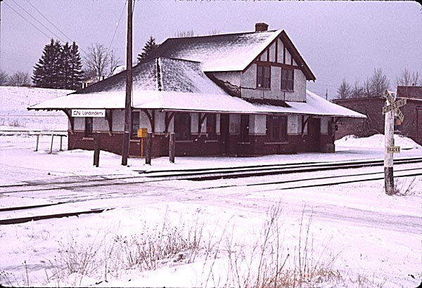 The Fucking CarSo how did we get from this solved problem to the mess we're in now? The car.And you can understand it. They didn't know the city would be blown apart by the car. There were a whole bunch of overlapping things that are hard to disentangle. How crazy were they? Please take a few minutes to check out these two videos from the dawn of the car-crazy era. These appear like some kind of extended joke to us now (if they don't appear that way to you, you probably want to stop reading now) but they were dead serious, this was the real capital-F Future they imagined.
Design for Dreaming (1956)
Disney (Disneyland TV) - Magic Highway USA (1958) Seriously. These people were out of their minds. They thought it was one step from curving ascending highways to flying cars and then rocket cars to the moon. They thought everything, without exception, should be automated, inconvenience eliminated, physical effort banished, spaces enclosed. Never go outside! Never walk! Man vs. Nature: The Road to Victory. It's hard for us to understand this - the people standing on moving sidewalks rather than walking from store to store, the car that flies right up to your office door - but we're simply too far removed. Washing used to be hard work. The washing machine was like a kind of miracle (as Hans Rosling argues in a great TED video). The car gave everyone transportation faster than a horse, more personal than a train. They had just crushed the Nazis with American jeeps and tanks and planes and bombs. American industry had saved the entire goddamn world. They were going to the moon. Can you imagine living at such a moment and not thinking you could just sweep away everything old, all the old musty city and build a shining new future? It's easy for us to sit in 2012 with fat kids and strip malls and cratered downtowns and wonder how they could have done this, but they seriously just saw it as another step, just more progress. The car replaced the train. The plane replaced the transatlantic liner. The bus would replace the tram. Everyone would be free, happy, rich, everyone a king in their own suburban mansion, commuting to shining city towers to work on space projects. You can see it in every frame of the above videos. They believed. No one sitting in their comfortable detached brick house in downtown Ottawa in 1950, living their comfortable middle-class life, walking and taking the trolley, thought "hey, let's add cars and turn this into a a bunch of crumbling crackhouses". They thought, out with the old, in with the flying cars and houses on the moon. And just about everyone made the same mistakes. The only difference is at what point they started to realise what they were doing, and work to undo the mess. And even then, even in the most difficult places to have a car, people love their fucking cars. In New York where it is incredibly inconvenient to have a car and a parking space might cost you as much as a Canadian suburban house, they love the car. In France, where you pay high gas taxes and high road tolls and high parking fees and you have endless transportation alternatives they love the car. Beautiful walkable transit-friendly Paris is jammed with cars. Stockholm is full of cars. In fact about the only place you can see the less-car world is in Copenhagen, where beautiful women glide slowly by on bicycles on quiet streets, like something out of a dream. So let's have no illusions that it is easy to eliminate the car. But you can work to provide the alternatives. You can learn from the disaster that was the 60s and 70s (and which continues unabated in many places in North America, to the point where mayors in 2011 triumphantly crow about "ending the war on the car" as if the car hadn't blitzkrieged pretty much every aspect of pre-WWII urban life and culture into utter annihilation). The TramIn France they got rid of all the trams... and then started rebuilding the tram lines again in the 90s. Wikipedia - List of town tramway systems in France tells the tale:Mulhouse: closed 1956, rebuilt 2006 Strasbourg: closed 1960, rebuilt 1994 Bordeaux: closed 1958, rebuilt 2003 Dijon: closed 1961, rebuilt 2012 (expected) Rouen: closed 1953, rebuilt 1994 Toulouse: closed 1957, rebuilt 2010 Valenciennes: closed 1966, rebuilt 2006 Nantes: closed 1958, rebuilt 1985 Nice: closed 1953, rebuilt 2007 Grenoble: closed 1952, rebuilt 1987 Lyon: closed 1956, rebuilt 2000 You get the idea. Meanwhile Ottawa: closed 1959, rebuilt ???? and no, that is NOT rebuilt 2017 or 2019 or whatever the Ottawa "LRT" date is. The old proposal, the previous proposal I tried to be very clear about the different transportation modes above, about the solved problem of transporting people, because it seems Ottawa is incapable of understanding this distinction. A train that runs above ground is not a tram. If it has stations far apart and is designed to move people from the suburbs in and out of the city core, it is commuter rail. Ottawa is building commuter rail. A little tiny bit of commuter rail. That's it. The LRT will do exactly zero for people living downtown who want to move around the city the way actual residents do, which is between neighbourhoods: from the Glebe, to Centretown, to Westboro, to the Market. Those are the places people who like the urban space want to go. The LRT will not get them to any of those places. The LRT is for jamming even more commuters even more quickly in and out of the CBD. That's it. Whatever shall we do?If you want to do a proper Ottawa (transportation slice), what you do is: 1. rebuild at least the S and B lines of the Ottawa trolley (Didn't know we had a trolley system? It covered the entire downtown, and since it was for residents, not suburban commuters, it connected together the neighbourhoods of the city -- to some extent it helped create the neighbourhoods of the city.)  2. Run commuter rail out to defined town centres. And that's it. None of this "park and ride" BS. You want to ride the train? LIVE NEAR THE TRAIN. 3. Run local rail to local towns (that means towns far beyond 20 minute commuting distance). 4. Run high-speed rail Montreal-Ottawa-Toronto. It will cost $9 billion and pay for itself. How do I know this? Because the federal government told me, although they buried that info so far in layers of clicks and bottoms of paragraphs you would never know it. Developing the section between Montreal-Ottawa-Toronto could cost between $9.1 [billion] for 200 km/h and $11 billion for 300 km/h. ... a project between Montreal, Ottawa and Toronto only could generate a positive net economic benefit at both 200 and 300 km/hUpdated Feasibility Study of a High Speed Rail Service in the Québec City – Windsor Corridor (November 14, 2011) - emphasis mine and the central station for all this rail activity should be, you know, the central train station: Ottawa Union Station. 5. And yes of course, do a loop around to Gatineau (although the weird 60s inward-facing Place du Portage "employment node" really should be torn down, which would reduce the number of public servants who need to do the loop around). And run rail to the airport. These are also obvious and there is dedicated rail to the airport in London, Paris, Stockholm etc. etc. 6. In the space you gain from reclaiming the public transportation space from cars, widen the sidewalks and provide cycling lanes. The high predictability of rails-bound trams means that they very comfortably mix with pedestrians and cyclists. You may have noticed that I didn't mention a subway - you only need a subway (which is enormously expensive) if there are long-haul distances within the city that your existing transportation network can't satisfy. So IF you build the entire tram network and you find a lot of people still aren't able to get around within a 20 minute tram-ride window, then you think about a subway. But the Ottawa core is small and a long way from densely populated - from e.g. LeBreton Flats to Riverside Park you're only talking what, 7km and only a few tens of thousands of people? It's pretty hard to justify the expense of a subway through kilometres of rock just to save a few people a few minutes of travel time around the core. The disconnect between what I see as a straightforward transportation plan and our inability to act as a city is a tiny fraction of what drives me insane about the NCC Horizons 2067 and Centretown Design Plan and Downtown Moves (and whatever the hell Choosing Our Future is). You don't need some effing panel of experts. You don't need to consult and re-consult and re-re-consult until 2013 to decide what you will do in FIFTY-FOUR years from now. Just this transportation slice is not only obvious, but could be done within the span of years, not decades. Don't spend $2 billion on 12km of commuter rail and think you've saved the city. All that does is encourage commuters to live FARTHER away, and rewards developers who will jam the cheapest, tallest, ugliest towers near-ish to stations and call it "transit-oriented development". Build a whole entire network. You don't need a single new idea. Just remember 1950s Ottawa, 1950s Canada, and 2012 Europe. You want to fix our little lumber town that was never a city in the first place, that is never going to be Paris or London in some undefined "G8 Capital" sense, but that is at least a more functional space than the created-from-nothing planned city artificial capitals like Brasilia and Canberra? Just revisit the prosperous, functional 1950s city where public servants lived downtown  bring back some of the infrastructure that enabled that, and add the modern infrastructure that we have learned about in the last SIXTY YEARS. While you're at it, you might want to end the insane fantasy that 2760 square km spanning from the woods to central condo towers is a "city". 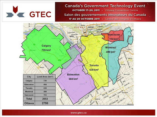 I have a lot more to say about the built-form issues and general suburban suck, but this is enough typing for now. Labels: ottawa, ottcity, rant, transportation planning, urban planning, urbanott, yow Thursday, January 19, 2012
Thoughts on Downtown Moves and Ottawa's urban future
The January 18, 2012 Downtown Moves Open House was a low-key event with discussions around display panels and large printed maps of the study area. I have posted photos of all the display panels (except for two where people put dots on their home & work addresses and problem areas for walking and cycling). Here are the display panels: Downtown Moves - Open House Jan 18, 2012. UPDATE: Now includes the five sections of the large handout from the event, at the end of the photo set. ENDUPDATE I was fortunate to have the opportunity to have a long chat with the city's planning lead on the project, Nelson Edwards. I spoke about the importance of having a lively streetlife, of having interest and activity in the lower three stories of buildings as they engage the street (Jan Gehl has said these lower levels are key, where people on the street can see what's going on above and vice-versa for people living above). Mr. Edwards has a very comprehensive perspective, but I worry that the Downtown Moves initiative is challenged with being all things to all people. At its very core, it's about taking advantage of the buses being (partially) replaced by underground LRT, so that the study area (the Central Business District) can both adapt to the new pedestrian flows, as well as becoming a better urban environment as a whole. You can get a sense of the challenge from the many, many "Strategic Directions" the project has declared for the study area:
I think the core thing to understand about the CBD is that it is not a failure. It was designed to be that paragon of Modernist planning: the single-use district. They believed in strict separation of their three functions: dwelling, work, and recreation. All to be tied together with their fourth function: transport. In practice what this resulted in was people living in detached single family homes out in the suburbs, with work clustered in "office parks" downtown and along highways, and recreational areas separated from both. They really thought that this idea of the city as a "machine" or "factory", where you would separate out each function and make it "more efficient" would lead to the best possible living, working, and playing environments. The modernists also thought that all functions of the city planning should be separate with parks planning separate from traffic engineering separate from etc. etc. Instead of this mechanistic, reductionist planning producing efficient paradises it created lifeless surburban zones where people stay inside their houses, connected to lifeless work zones where people stay inside their buildings, connected to recreational zones where people stay inside the stadium. And by "connected" meaning only highway upon highway as single-occupant cars rush from one "function" to another. And the idea of buildings actually engaging with their environment, being in a specific place with people flowing in and out at ground level becomes so alien and lost that all your buildings turn inward, with dead exteriors surrounding interior food courts and shopping; buildings that could be dropped anywhere. They were totally wrong. Hey, it happens. But the result is most Ottawa families living a car commute away outside the greenbelt in cookie-cutter suburbs sprawling outwards, a CBD that cars and transit rush as quickly into and as quickly out of as possible at 9 and at 5, a hockey stadium out in the middle of nowhere, and endless expense on the car transportation (and to a much lesser extent transit) network needed to connect these far flung islands together. Even the arts centre in the core of the city turns its back to the sidewalk, because who would ever arrive anywhere by foot? Instead it welcomes the car on the canal side, far away from the rabble of the street. Plus which Rideau Centre in typical inward facing "special zone" fashion sucks up all the destination retail. This would be hard enough if we had stopped doing it. But most housing still goes beyond the greenbelt. Most new buildings (e.g. 180 Kent) continue the same inward-facing food court mall placeless design that Place du Portage and L'esplanade Laurier exemplify. New condos are dropped in as vertical suburbs, single-use residential zones that could be anywhere, with no engagement with the street. And the entire thing is held together with a network of high-speed city core "arterial" roads that makes the entire downtown an offramp. To unwind this deliberate 1960s successful design, we need to stop 50 years of assumptions, engineering and design. Many cities started doing this over two decades ago in the 80s and 90s. We have barely started to attempt it now, in the second decade of the 21st century. It will be a long long walk home. We've got the bones (and culture) of a small town with a couple main streets. We've got the housing of a small town that was packed with middle-class government employees. (See Residence Distribution of Civil Servants, 1947 from the Gréber Plan.) And we have the design of a wave of 1960s brutalism, "urban renewal", and Modernism, that left us with a city core stripped of inhabitants, a street rail system that was erased from the map, and the suburbs, malls and associated car infrastructure that swept across North American cities. I see this most often in the endless discussions around Sparks. Sparks had surface rail running down the middle, with destination shopping (the Apple Stores and Lululemons of their age) on either side. It connected Lebreton Flats to Lowertown and to the destination shopping on Rideau Street. It was surrounded by a dense grid of housing for civil servants, shop keepers and all the people who live in a typical central town. Then they took away the rail, all the destination shopping went to Rideau Centre, they flattened Lebreton, Lowertown crumbled into a low-income disaster area (like most city cores), all the rest of the people living downtown fled to the suburbs, and they dropped cold inward-facing office towers around Sparks. And people wonder why it doesn't work? It's a wide pedestrian street that connects nothing to nothing, with no shopping and no people who live nearby. In a real world where people like to move along edges, and watch other people. Is this seriously hard for people to understand? It's a pedestrian street in the middle of what might as well be a suburban office park. OF COURSE NO ONE WALKS THERE. Look at the reality It's a bunch of offices (pink colour) 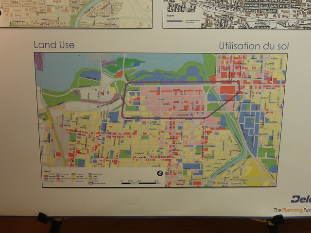
fed by a network of high-speed arterials (red lines) 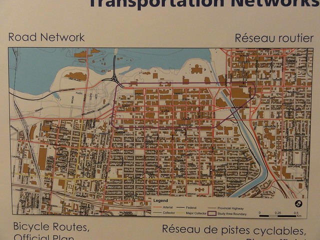 Dedicated zones like this, with public space (that is to say, the streets) dedicated only to ensuring people can drive in and out AS FAST AS POSSIBLE are Dead by Design. You might as well stand at a strip mall by the Queensway and wonder why it isn't like being in downtown Paris. It will take decades of effort to unwind this. For example, the single biggest thing you can do to make this a place for the people who actually live there is to slow down traffic. It is insane to have high-speed traffic in a downtown core, a centre-ville. Over 30km/h, cars vs. pedestrians and cars vs. cyclists ends with dead citizens. That means you have to signal to people, through road design (not through signage or laws, which people ignore), through the design of the streetscape itself, that they not on the safe wide highway, that they have to slow down and pay attention, that they are now not the lords of carland, they are visitors to a pedestrian zone. Just that alone, trying to narrow and slow streets, returning them to their pre-1950s widths with attractive street features and enough uncertainty so that drivers go slowly with care, will be a huge, incredible fight. How do I know this? Because King Edward already tried to do this, and Bronson is trying to do it now, and the traffic engineers return instead with ever-wider, ever-faster, ever-more-highwaylike designs. This is not surprising, they are TRAFFIC ENGINEERS. Their purpose is to make the cars go faster and the traffic flow smoothly. Expecting them to produce traffic-slowing pedestrian designs is like expecting a pastry chef to design an aircraft carrier. If the city believes "Rebalanced and Equitable" streets, that means rebalanced and equitable planning. That means for every traffic planner, there should be a pedestrian planner, a cycling planner, and a transit planner. That's how you actually get to "rebalanced". This is not about hating cars or towers. This is about building a city, not a giant strip mall. Urban design is different from suburban design. The role of the car downtown is different. The way residential towers need to engage with the street is different. For that matter, the way people need to think about their city and move around it is different. There is a big risk that, as with the dead street life around the apartment towers full of thousands of people on Laurier west of Kent, if we drop more towers on Nepean and Gladstone near Elgin without using design and education to convey to people that they are in a city where they can walk around, shop, and live outside in the city, we'll just end up with a downtown that has "foot commuters" who pour out of residential towers, up into officer towers, and back again, without ever stopping to experience the city they're actually in. If you think this is theoretical, there are thousands of units in condo towers already approved, with many of the towers under construction right now. 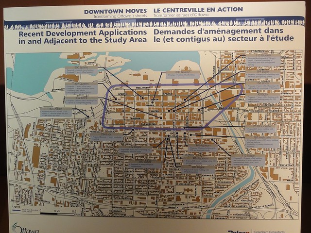 The only way I can see to chip away at this realistically is: 1) The city must hire more dedicated pedestrian, cycling and transit planners (it has already taken great stride in hiring cycling planning, but has zero pedestrian planners). 2) The city must convey the idea, both through explicit statements and implicit design, decade by decade, that cars are visitors to the downtown, not the owners of downtown, and that they are welcome only to the extent that they respectfully share public transportation space with other users 3) The city must have zoning it can ENFORCE, design it can ENFORCE, and plans that are actually followed, in a way that is comprehensible to ordinary humans (as opposed to the current situation where developers build whatever they want wherever they want to the lowest possible standard, and use layer upon layer of city, NCC and other planning documents to win their case every time at OMB) There is so much more than even these basic steps. This is basically the project of the redevelopment of the entire urban design for the city. I am skeptical about what can be accomplished. I hope at least that it can move on three fronts, with small "popup" demonstration projects, enforced standards for new buildings, and a long term plan to make the city environment better as buildings are replaced and streets are upgraded. You can reach Nelson at Nelson Edwards Planning and Growth Management Department Infrastructure Services and Community Sustainability City of Ottawa 110 Laurier Street West Ottawa, ON K1J 1P1 Tel: 613-580-2424 ext. 21290 Fax: 613-580-2459 e-mail: downtownmoves@ottawa.ca You can sign up for the Downtown Moves mailing list. The city's website section for the project itself is ottawa.ca/downtownmoves This is a huge change in city direction. It needs every citizen pushing their councillors, city staff, and engaging in the planning process to help it happen. Labels: dottmo, downtown moves, ottawa, urban planning Sunday, January 15, 2012
Downtown Moves meeting January 18, 2012
Downtown Moves, which is the new name for the Downtown Ottawa Mobility Overlay, is having its second meeting Wednesday, January 18, 2012 5:30 to 8:30 pm Ottawa City Hall, Jean Piggott Place, Main Floor 110 Laurier Avenue West This is the second in a series of public events that will provide residents with an understanding of the study, what it hopes to achieve and how it will transform Ottawa’s streets over the next 20 years.The short URL is ottawa.ca/downtownmoves I'm using the Twitter hashtag #dottmo for the initiative. The previous events were more like stage-setting presentations, they didn't really delve into the project itself and its goals. What I would like it to be is: transforming the Central Business District (CBD) from a Monday-Friday 9am & 5pm commuter suburb in the core of downtown to a pedestrian-friendly 24/7 core with streetlife, connected to the Market, Centretown (south of the CBD) and Lebreton Flats. What I expect it will actually be is: How can we move commuters coming to/from the LRT stations out of the way of cars and in/out of their work towers as quickly as possible, while making some minor concessions to the fact that there are no longer buses on Albert & Slater. This is particularly important as Claridge and others have built a lot of condos in the area recently and are continuing. Just in the next few years another 2000 or more condo units will come online, mostly dropped into the CBD in giant towers. In theory, Downtown Moves should take into consideration the Centretown Design Plan, most specifically the recommendations that the downtown core arterials (particularly Lyon, Kent, O'Connor and Metcalfe) be made two-way. However the study scope is so narrow (just the CBD, just related to post-LRT) that I fear the Design Plan ideas will be lost. The short URL for the CDP is ottawa.ca/midcentretown but most of the information is in their blog in particular their final post: The FINAL Centretown Community Design Plan Has Arrived! (I hope the blog is archived, as the site and URLs will surely expire at some point.) There are many other relevant documents including the Pedestrian Plan and the Cycling Plan. I thought Greenberg's presentation from the previous meeting was going to be posted online, but I can't find it. I captured an archive of the November events and livetweeted Greenberg: Downtown Moves - Nov 1-3 Twitter archive. His book Walking Home is excellent. Highly recommended. Covers how the suburbs ate the cities, and how we can walk our way back to lively, people-friendly urban design. Ottawa has had no shortage of outside experts providing us excellent advice on modern urbanism. Where it falls apart is in two places: 1) Implementation using our actual city staff in our actual city 2) Funding and defending our decisions (e.g. enforceable zoning rather than development-via-OMB). Friday, November 04, 2011
Downtown Moves - Nov 1-3 Twitter archive
Below is the raw extract of tweets hashtagged #dottmo Context: Ottawa.ca - Downtown Moves (Downtown Ottawa Mobility Overlay Study) Most of them are from the Ken Greenberg talk, I have separated out earlier ones at the top. These are in oldest first order. (In case you're wondering how I did this, I took the Excel version of the Twitter archive I made, and sorted by ascending TweetID. then copied the text.) Where the tweets are in order, just from me and the date is the same, I have removed my Twitter handle (@rakerman) and the time stamp. Tweets from before Ken Greenberg's talk@rakerman2011-11-01T11:15:54-04:00 questions: how Centretown Design #ccdp2011 Mobility relates to Downtown Moves #dottmo & Sidewalk Summit #ssdh http://t.co/OE8p55rY #ottcity I'm proposing #dottmo for Downtown Moves (hashtag = Downtown OTTawa MObility/MOves/Mobility Overlay) #ottcity @rakerman 2011-11-02T20:29:26-04:00 @OTWPolitics I suggested hashtag #dottmo @rakerman 2011-11-03T06:02:53-04:00 I will be using hashtag #dottmo for Downtown Moves / Mobility Overlay #ottcity #dottmo MT @OTWPolitics: For those who can't make it to City Hall tonight, Ken Greenberg's talking urban rejuvenation on @CBCOttawa @Centretowner 2011-11-03T08:19:33-04:00 RT @rakerman: I will be using hashtag #dottmo for Downtown Moves / Mobility Overlay #ottcity @Centretowner 2011-11-03T09:10:47-04:00 Anyone else tweeting from Downtown Moves talk by Andrew Wiley-Schwartz? #Ottcity #dottmo #ottbike @Centretowner 2011-11-03T09:12:44-04:00 Coun. @marianne4kanata talking about making our roads safer, and @JimWatsonOttawa signing Int'l walking charter #dottmo @JimWatsonOttawa 2011-11-03T09:24:34-04:00 RT @Centretowner: Coun. @marianne4kanata talking about making our roads safer, and @JimWatsonOttawa signing Int'l walking charter #dottmo @lana_stewart 2011-11-03T09:35:37-04:00 @Centretowner @rakerman They talk the talk... but will they walk the walk?? #ottcity #dottmo @Centretowner 2011-11-03T09:39:06-04:00 AWS's #dottmo talk about what NYC did at Times Square reminds me of what #Ottcity did in the '60s with Sparks St Ken Greenberg spoke November 3, 2011 at 7pm at City Hall. Context: Ottawa.ca - Downtown Moves - Public Lecture Program Ken Greenberg's talk@rakerman2011-11-03T19:01:15-04:00 #dottmo just opening - Ken Greenberg talking about book #dottmo "we were swept up in a euphoria around the potential of the automobile" #dottmo 1939 World's Fair - GM exhibit - "it seemed like a good idea at the time" #dottmo "the hubris of that era... The automobile was at the heart of it" #dottmo Disney Magic Highway USA 1958 #dottmo the summary of the Disney film is people were out of their minds (about cars) in the 1950s #dottmo from walkable cities to car-oriented cities #dottmo Jane Jacobs vs Robert Moses #dottmo as walkability becomes the most desired, poor are pushed out of city centers into suburbs #dottmo (car-centic design) producing a pattern of living that is not sustainable #dottmo massive financial drag on economy related to congestion, long car travel times #dottmo website: dead malls (symptom of car-oriented design failing) #dottmo "the best way to solve mobility is through land use" #dottmo need mixed use buildings #dottmo Bank Street Ottawa transformation #dottmo how to handle new immigrants - they are now ending up in suburbs - disconnected, difficult to get around #dottmo (me: in part this is about the Arrival City idea) #dottmo showing transformation of NYC Times Square #dottmo Madrid has buried city-centre highways #dottmo new ways to get around - bike share, car share, phone as access/payment for all forms of transportation #dottmo showing a Complete Streets design #dottmo if kids can bike to school, that's a good indicator #dottmo urban design to percentage of pedestrians using the space - temporary or permanent pedestrianization of roadways #dottmo Hammarby Sjostad http://t.co/vRFX82t5 #dottmo the next big challenge: retrofitting suburbia #dottmo #ottcity is there a link for the Bank Street redesign Ken is talking about? #dottmo restructuring around subway stops coming to York U #dottmo Mississauga "looks like a city... But on the ground it's auto-oriented" #dottmo "at the heart of a sustainable future is gracefully making this transition" to a pedestrian/cyclist/transit city #dottmo civil society needs to support these changes #dottmo iterate solutions with teams of experts to solve complex urban design problems #dottmo big turnout, mailing list I can sign up for, but not at all clear how people can participate, not just receive broadcasts #ottcity #dottmo I guess Ken Greenberg was talking about: Bank Street Community Design Plan http://t.co/u38bi6xL 1st I've heard of it. #ottcity #dottmo Here's the Disney Magic Highway video that Ken showed, demonstrating how crazy people were over cars in 1958 http://t.co/ZMSDVvWj Further ReadingI think this is what the Mayor signed: The International Charter for WalkingRandomHouse.ca - Ken Greenberg - Walking Home: The Life and Lessons of a City Builder LibraryThing - Walking Home: The Life and Lessons of a City Builder Wired 15.12 - The Original Futurama [GM 1939 World's Fair exhibit] Wikipedia - Jane Jacobs - The Death and Life of Great American Cities RandomHouse.com - Wrestling with Moses: How Jane Jacobs Took On New York's Master Builder and Transformed the American City LibraryThing - Wrestling with Moses: How Jane Jacobs Took On New York's Master Builder and Transformed the American City Arrival City: The Final Migration and the Next World US National Complete Streets Coalition Complete Streets Canada I would point you to a fantastic video of Jan Gehl talking in Ottawa about urban design, but the NCC reorganised their site and it has now disappeared. You can see his slidedeck but it's almost useless without his (very funny) narration. You can also follow the thread of blog postings back from Jan Gehl presentation about urban planning in Ottawa - October 6, 2010 but many of the links are now broken. ContactThere is a general contact address: downtownmoves@ottawa.caand the specific project manager is Nelson Edwards: nelson.edwards@ottawa.ca There was a mailing list you could sign up for at the event; you can probably get on it by emailing them. Nelson said on the afternoon of the 3rd there was a 40-person discussion / working group, but I don't know who the members were or how the results will be presented. Also Greenberg's presentation was recorded in some form - I think video - there was mention of a "podcast" of it being posted. Previously: November 1, 2011 questions about downtown mobility [now with answers] Labels: centretown, dottmo, downtown mobility, downtown moves, links to presentations, ottawa, presentation notes Wednesday, November 02, 2011
Ottawa - Centretown walkability
As you walk around town between now and November 8th, consider the following topics and if possible please bring a list of 5 examples in each category.Here are a couple: * The Bank Street advertising monoliths that block half of the sidewalk * The traffic signal control nodes (big boxes, usually sitting on a metal column) that block half of the sidewalk Labels: centretown, ottawa, urban planning Tuesday, November 01, 2011
cat missing near Dundonald Park
 Shreddy. Above is from a few months ago; she looks a bit older now. She doesn't have a collar on at the moment but she is chipped. As you can see, grey with white stripes and white paws. UPDATE 2011-11-02: Found late in the evening, she was stuck on the wrong side of (very busy arterial) Lyon. Labels: cat, centretown, ottawa
questions about downtown mobility
This is what I asked on the Centretown Design Plan blog: Will you be representing the Centretown Design Plan at the Downtown Moves (Mobility Overlay) events? http://ottawa.ca/residents/public_consult/mobility_overlay/program_en.htmlUPDATE 2011-11-03: I got a response (Ross at the Mid-Centretown Tomorrow blog has always been great with fast, detailed responses).
With regard to your questions around the Mobility Overlay, your best bet for answers and understanding how transportation networks might be improved and/or impact on adjacent communities is to contact Nelson Edwards at the City of Ottawa (nelson.edwards@ottawa.ca). Nelson is the project manager and will have the most recent information on the scope and methods of the study. It was our understanding that DOMO was to look at the two way conversions as part of its scope. I hope that this is still the case. As you know, Centretown has been included as the Area of Influence….but I am not really sure what this means with regard to work being undertaken locally. All the best Previously: October 31, 2011 Downtown Moves - Public Lecture Program - Nov 2 & 3, 2011 October 31, 2011 Ottawa Sidewalk (pedestrian) Summit Nov 8, 2011 Labels: ccdp2011, ottawa, urban planning Monday, October 31, 2011
Ottawa Sidewalk (pedestrian) Summit Nov 8, 2011
Diane Holmes' "SIDEWALK SUMMIT"from dianeholmes.ca You may also want to consider trying to connect this up with the overlapping but apparently disconnected work being done by the Centretown Design Plan, the Downtown Mobility Overlay (apparently now called Downtown Moves: Transforming Ottawa's Streets), Choosing Our Future and NCC Horizon 2067. See also: Downtown Moves - Public Lecture Program - Nov 2 & 3, 2011 UPDATE 2011-11-01: Also of note is the Ottawa Pedestrian Plan, marked draft 2009. ENDUPDATE Previously: May 30, 2011 Centretown planning links Labels: ottawa, urban planning Monday, May 30, 2011
Centretown planning links
Trying to untangle the layers of Centretown planning requires obsessive trail-following and link-collecting. Here's what I've found. Mid-Centretown Community Design PlanSee Centretown Design Plan - feedback by June 13 for info on the draft report. The Escarpment Area District Planhttp://www.ottawa.ca/residents/planning/community_plans/completed/escarpment/index_en.html Downtown Ottawa Mobility Overlay (DOMO)The Downtown Ottawa Mobility Overlay ("DOMO") will be much more important in determining the street-level life - the community design plan can feed recommendations into it but it will be DOMO that sets the final transportation plan. The community design plan is recommending fixing the high-speed downtown arterials (Metcalfe, O'Connor, Kent, Lyon) by making them two-way and other traffic calming - this would be awesome but will be a big fight. http://ottawa.ca/residents/public_consult/mobility_overlay/index_en.html (ignore the 2010 part on the above page, the study starts fall 2011) Ottawa East-West Light RailUnderstand the LRT as a commuter rail system (like the RER in Paris), not as a subway or a tram system. It will benefit commuters but will have very little impact on the downtown transit experience (in some ways Transitway access will be worse, as it is six escalators down from the surface to get to e.g. the Rideau platform). This is the latest info on the LRT plan "City of Ottawa Light Rail Transit System - May 2011" http://ottawa.ca/calendar/ottawa/citycouncil/ptac/2011/05-19/OLRT%20May%20Ped%20Cycl%20&%20Transit%20advis%20cttee.pdf Cycle Friendly OttawaThe "Cycle Friendly City" motion says "Ottawa implements policies that favour walking, cycling and public transit over the use of private motor vehicles". City of Ottawa policy on walking Pedestrian consultationDiane Holmes is doing some sort of event in June about making Centretown more pedestrian-friendly but there's nothing up on her website yet Here's the article she wrote Centretown Buzz - Planning to put pedestrians first and here's her office contact info http://www.dianeholmes.ca/detail.php?id_holmes=29 UPDATE 2011-11-01: There is an Ottawa Pedestrian Plan, marked draft 2009. Also Diane Holmes' event will be November 8, 2011. ENDUPDATE Ottawa Cycling PlanThere's a fully-approved Ottawa Cycling plan, most of which hasn't been implemented. http://www.ottawa.ca/residents/onthemove/cycling/ottawa_cycling_plan_en.html Laurier Segregated Bike LaneThe Laurier dedicated cycling lane is at least proceeding with a two-year trial http://www.ottawa.ca/residents/public_consult/bikelane/index_en.html How do you find out about planning?I don't know how a Centretown citizen would be expected to pull all this info together. Whatever the NCC is doingThe NCC is also doing a bunch of other stuff but trying to untangle it would make my head explode. There's this Choosing Our Future thing that is some kind of input into some Horizon 2067 thing and some cycling thing and aieeeeeeeeeeeee http://www.choosingourfuture.ca/index_en.html Horizon 2067 http://www.canadascapital.gc.ca/bins/ncc_web_content_page.asp?cid=16300-20443-136853&lang=1&bhcp=1 Labels: ottawa, urban planning
Centretown Design Plan - feedback by June 13
The Mid-Centretown Community Design Plan has been renamed "Ottawa Centretown: A Community Design Plan for the Heart of Centretown", it's a 51MB PDF. Draft Centretown Design Plan (May 27, 2011) from the Mid-Centretown Tomorrow blog: The Draft Community Design Plan is Available! You can leave feedback as a comment to the blog post by June 13, 2011. Note: If you're viewing it on an iPad (or an iPhone) many of the images do not render, showing either as blank pages or as diagrams with labels but no content. There will be a final Open House on Wednesday June 29th at the Museum of Nature. There's a lot of good stuff in here, and I will have more to say later, but if you want to jump right to the proposed zoning changes, they're on page 107 (page 111 of the PDF). A residential tower zone (which they call "residential apartment neighbourhood") of up to 27 storeys (83m) is proposed from Gloucester down to between Cooper and Somerset. I think this is fine and reflects certain realities on the ground. A further high-rise district is proposed near Catherine (up to 77m in height). Between Catherine and Somerset either existing zoning is retained or new clear 7 to 9 storey zoning is proposed. The only part I disagree with is their "Traditional Mainstreet" type e (27 storeys) on Bank and Kent north of the midline between Cooper and Somerset. While this is their residential apartment zone dividing line, I don't think 27 storeys is appropriate along a mainstreet segment even as it heads into the CBD, and it doesn't align with their recommendation of having height mainly on east-west mid-blocks. Labels: ccdp2011, ottawa, urban planning Thursday, May 26, 2011
Copenhagenize in Ottawa June 3, 2011
Mikael "Copenhagenize" Colville-Andersen will speak about urban cycling at noon on June 3, 2011 in Ottawa.
from http://www.cycling-vision.ca/events/ You can also see Mr. Colville-Andersen cycling around Copenhagen with David Suzuki. His blog is http://www.copenhagenize.com/ and he tweets @copenhagenize Labels: cycling, ottawa, urban planning Friday, April 08, 2011
Ottawa Sun article on Downtown Ottawa Mobility Overlay
Downtown facelift planned - Ottawa Sun - Friday April 7, 2011
Previously: 2011-04-01 Downtown Ottawa Mobility Overlay Labels: ottawa, urban planning Friday, April 01, 2011
Downtown Ottawa Mobility Overlay
The Statement of Work for the Downtown Ottawa Mobility Overlay will be presented at Transportation Committee on April 6, 2011. The background text says
This will be a very important study for the future of a walkable downtown Ottawa. In Broader Issues to be Addressed they state
I also found the following paragraph interesting, considering they have loaded up the Bank Street sidewalks with all this junk, even post-redesign (the giant ugly ad monster tower things are the worst offenders, but there's lots of other stuff in everyone's way too).
Key Mobility Overlay Milestones
Labels: ottawa, urban planning Monday, March 07, 2011
City of Ottawa policy on walking
It is ridiculously difficult to follow a trail of decision-making on the ottawa.ca site - in fact there is no trail, as nothing is hyperlinked, so you have to navigate full-text document after full-text document, figuring out the connections yourself. In any case, my trail ended up a City Council September 8, 2010
from http://ottawa.ca/calendar/ottawa/citycouncil/occ/2010/09-08/englishminutes96.htm This follows on from a motion carried at Transportation Committee on September 1, 2010: http://www.ottawa.ca/calendar/ottawa/citycouncil/trc/2010/09-01/disposition44eng.htm @centretowner tells me this should not be interpreted as a priority list e.g. it's not 1. walking 2. cycling 3. public transit 4. private car it's 1. walking, cycling, public transit 2. private vehicle The Mid-Centretown Community Design Plan consultation has a bunch of ideas about how to implement these stated priorities in downtown Ottawa, see their presentation (PowerPoint, 11MB) starting at slide 28 (from November 30, 2010). Also see their draft mobility position paper (PDF). Apparently the city is going to do a Downtown Mobility Overlay study, but there doesn't seem to be any info online yet. Labels: downtown mobility, ottawa, pedestrians, urban planning, walking Sunday, March 06, 2011
Jan Gehl presentation about urban planning in Ottawa - October 6, 2010
I am glad that NCC (finally) posted video of Gehl's talk online - it's great. Here it is at giant NCC URL. You can also get the slides from his presentation (although you would never know this from navigating the cycling site). Note: There's no way to make the video full-screen; I think the NCC should use a different player and put the content on YouTube or some other video site as well. The NCC has also improved its Cycling in Canada’s Capital Region page with better links to the work it is doing, although they STILL don't link to the PDFs of cycling-presentations (including Gehl's) that they host on their own site. Previously: Wednesday, October 20, 2010 NCC cycling presentations - including PDF of Gehl's presentation Saturday, October 09, 2010 Jan Gehl in Ottawa - my livetweets from the event Labels: cycling, links to presentations, links to video, ncc, ottawa Wednesday, November 17, 2010
Mid-Centretown Design Plan - come out Nov 30, 2010 to discuss
The Mid-Centretown Community Design Plan Community Open House Tuesday November 30, 2010 Iona Hall, Knox Presbyterian Church 120 Lisgar Street Open House: 5:30 to 8:30 p.m. • Presentation: 6:30 p.m. http://midcentretown.wordpress.com/2010/11/12/join-us-on-november-30th/ This is important for anyone who is concerned about improving downtown Ottawa. Incidentally, the consultants have been doing a great job with their blog - I recommend you check out their posts, and provide them with comments/feedback. Labels: ottawa, urban planning Sunday, November 14, 2010
attempting to go to Urban Capital event about Architecture
Urban Capital is doing a 5-night series of events called Trends in Design. They're a developer and in Ottawa the event is in their (small) sales centre for the "Central" condominium complex. I have a lot of respect for the fact Urban Capital has built Mondrian at the north end of Bank and is now building Central - they are really going to lift up the street and the entire area. That being said, they clearly have a strong self-interest in getting a bunch of people who are interested in urbanism and architecture into their sales centre. I also have to say, for a series of events about design, the event info and signup is an example of a truly awful Flash user interface. * You can't link to the event or individual nights directly * The event pages don't list what night * You can only see the event one night at a time (one night per screen) * The signup page only lists events by night, not by description * For sold out events the date simply disappears So the workflow to sign up is: * Go to Urban Capital * Click on Trends in Design * Click on 5 Nights * Click on Next to get to Night 2 * Click on Next to get to Night 3 * Click on Next to get to Night 4 * Decide date looks ok, but there's no time listed? * Click on Back * Click on When and Where * Click on Ottawa * See it is "6:30pm cocktails, 7:30 event" (I would copy & paste this from the site, but it's Flash, so I have to type it in manually) * Click on Tickets * Click on Buy Tickets * Try to remember what night it was you wanted to go to, since it only lists nights, no other information * (Probably click back around through the nights in order to remember which one) * Click on e.g. Night 3 * Enter a bunch of info Urban Capital doesn't need to know * Click on $20 or $80 or whatever * Click on Pay Now * Go to PayPal and login or re-enter your name etc. for credit card * Receive automatic email confirmation from PayPal (with no info about the event) * Do not receive (at least so far) any automatic confirmation about the event itself, say listing the date & time as a reminder I think it may be the worst event info / ticketing UI I've ever seen. In any case, the events were/will be NIGHT 1 | SEP 16 2010 Fashion Trends by Lara Ceroni, editor at ElleCanada.com NIGHT 2 | OCT 28 2010 New Thinking in Designing Cities by George Dark, Partner at Urban Strategies Head NIGHT 3 | NOV 25 2010 Where Industrial Design is Taking Us by Julian Goss, Program Chair of Industrial Design Department at the Ontario College of Art & Design NIGHT 4 | JAN 27 2011 Architecture in Our New Century by Robert Claiborne, Design Lead at Cannon Design Lead Architect NIGHT 5 | FEB 24 2011 Interior Design Thinks Small by Cecconi Simone, Partner at Cecconi Simone Interiors (from Modern Ottawa - Trends in design coming to Ottawa) The remaining ones are all 6:30pm cocktails, 7:30 event at the Central sales centre 453 McLeod Street (at Bank) Modern Ottawa also did a brief review of the New Thinking in Designing Cities presentation - Trends in Design : Night 2. Labels: ottawa, urban planning Wednesday, October 20, 2010
NCC cycling presentations
You might think that the place to look for cycling presentations would be http://www.canadascapital.gc.ca/biking but they're not there. Instead go to http://www.canadascapital.gc.ca/ and follow Plan->Transportation NCC: giant ugly URL to two slide decks: What Makes a Bicycle-Friendly City? by Ms. Inge Molenaar, The Hague’s leading expert in cycling infrastructure. The presentation is called Cycling in The Netherlands and The Hague (PDF). From December 7, 2009 Cycling as Part of Urban Living: Public Presentation was the supposed topic of the presentation by Jan Gehl, but actually he gave a fantastic presentation about his new book, Cities for People (PDF). I tweeted from this session, and I've asked the NCC now twice if they could post the video of Gehl online (I'm pretty sure they were recording it, I was sitting right next to the video cameras) - so far I've gotten no response. UPDATE: These are some of the past and future cycling planning things from the NCC, Gatineau and Ottawa...
from NCC and Cities to Place Cycling at the Heart of Capital Region Labels: cycling, links to presentations, ncc, ottawa Saturday, October 09, 2010
Jan Gehl in Ottawa
Here's a transcript of my tweets about Jan Gehl's presentation on October 6, 2010. Although it was promoted by the NCC as part of their bicycling planning (Cycling as Part of Urban Living: Public Presentation), he actually talked about the history of urban planning and related disciplines, and the thinking he has developed that led to his new book Cities for People (there were supposed to be copies of the book for him to sign, but they weren't there due to some snafu). They were filming it, I hope they put it online. The NCC seems a bit social media challenged (no Twitter feed, no blog, no videos - not even a place online where you can sign up for a mailing list). The first tweet was 6:58 PM Oct 6th, 2010 and the last one was 8:51 PM Oct 6th. Other people tweeted as well, but they weren't using a hashtag. Tweets from my account @rakerman: at @MuseumOfNature for NCC Jan Gehl event. in absence of info I declare tag to be #nccgehl - good turnout. Cities for People #nccgehl http://twitpic.com/2v8mrn cool to see such a good turnout in #Ottawa to hear Jan Gehl speak #nccgehl Wikipedia - Jan Gehl http://bit.ly/aTZd3j #nccgehl Mayor of Gatineau is here #nccgehl standing room only #nccgehl new #NCC 50-year city vision plan will include urban mobility component #Ottawa #nccgehl Jan Gehl talking about importance of human-scale space #nccgehl Jan Gehl's book Cities for People http://amzn.to/bjkThO #nccgehl "a good city is like a good party" - Jan Gehl #nccgehl Jan Gehl is funny #nccgehl Jan Gehl talking about his training 50 years ago - modernism - must always separate zones - cities bad #nccgehl Jan Gehl talking about Le Corbusier #nccgehl from very slow development concerned for people to very fast building around 1960 #nccgehl big scale "professional" urban planners car invasion circa 1955 #nccgehl cars arrived in cities like a tsunami circa 1955 - Jan Gehl #nccgehl started thinking purpose of city planning was making room for cars #nccgehl Gehl cites Jane Jacobs #nccgehl "the Brasilia Syndrome" - city planning from 5km above the ground - technocratic #nccgehl from the airplane Brasilia looks smashing - Jan Gehl #nccgehl Brasilia completely ignored human scale - at human level it's "shit" - Jan Gehl (yes he said shit) #nccgehl planners didn't help... #nccgehl ... but architects also became obsessed with form over function #nccgehl Gehl has lots of criticism for "buildings dropped from the sky" architecture in Dubai #nccgehl now we come to traffic planners - Jan Gehl #nccgehl - their purpose was to make cars happy cities have traffic departments with wonderful statistics #nccgehl - cars very visible in planning process landscape architects at least are working at eye level - but not so interested in function #nccgehl who is left to look at the human dimension? #nccgehl pedestrians tend to be invisible in city planning #nccgehl Gehl flagging architectural renderings that show spaces full of happy people #nccgehl Gehl is hilarious #nccgehl the most important scale of all is People Scale - eye level at 5km/h #nccgehl more and more private space lost public space #nccgehl the number 1 attraction in cities is other people #nccgehl Jan Gehl talking about about Copenhagenizing New York #nccgehl 300km of bicycle lanes added in New York in 2 years #nccgehl I gave a standing ovation #nccgehl Q about where funding came from. A bicycle infrastructure is cheap #nccgehl Gehl talking about current cyclists in parts of North America : small percentage of cyclists high-speed cyclists on racing bikes #nccgehl Thanks to TwapperKepper for the archive http://twapperkeeper.com/hashtag/nccgehl - I used Export to get the tweets into a spreadsheet so they would be in FIFO order. Labels: books, jan gehl, ncc, ottawa, urban planning Sunday, June 20, 2010
fact-finding trips & social media:
Ottawa Citizen - NCC boss talks cyclable city - June 19, 2010
Ottawa Citizen - Could Ottawa get Copenhagenized? - June 20, 2010 So Lemay, Bureau & Legendre are going on an urban cycling fact-finding trip. First let me say, I am 100% in favour of this. Learning from other cities by visiting them is an excellent way to truly understand what is possible. And so when they come back bolstered by personal experiences, shared information and new connections, I think that is of huge benefit to the NCR. But. This is a major initiative. 10 days, concluding with Velo-city 2010 in Copenhagen, is a huge fact-gathering project. Velo-city is an event that has been building off and on for the past 30 years. And we have a traditional system: we elect or appoint representatives, and they go off and worry about 100% of the issues as our representatives, while we go about our lives. There are reasons for this: * in the past it was impractical for representatives to communicate rapidly with constituents * constituents are busy and not experts * we want representatives to be reflective and not reactive But.
Douglas Adams, The Hitch-Hikers Guide to the Galaxy This is 2010 and we have social media. Which means that you can share what you are observing. You can share it in real-time, or you can share at the end of the day, or the end of the week. You can also still follow a traditional process which is some combination of: * you take your own private notes and they inform your own private decisions * you present about your findings but only to your colleagues * you eventually produce a Great Big Report which is poorly announced and buried many levels deep (on your website and in the bureaucracy) so only political insiders ever find it and read it So here's the thing: I think if you're going to send a bunch of representatives off to find facts, in 2010, it is encumbent upon them to engage the public in the process. That means reaching the public through traditional means, like the news reports cited above, and through consultations like ottawa.ca/bikelane (which has a ton of information, as PDFs, at the bottom of Open House 1), and through posting your Great Big Report. But is there no responsibility to bring people along with you on your journey? Is engagement just about your personal learning followed by a Great Big Report? While it's true that many urban planning enthusiasts and cyclists will not be reached online, many are. If the information is online it can be shared, emailed, retweeted, blogged about, cited on Wikipedia... it can be used by citizens. This sharing can expand the scope of information beyond the hard core of people for whom this is a primary interest, to the broader public. Just look at the list of urban issues blogs and sites, just related to the Mid-Centretown consultation (from the Mid-Centretown planning blog): * Apartment 613 * Blogawa * Capital Neighbourhoods * Designing Ottawa * Greater Ottawa Blog * Images of Centretown * Modern Ottawa * Ottawa Meme * Ottawa SkyscraperPage Forum * Somerset Street West Today * Spacing Ottawa * The Ottawa Project * Urbsite * Watawa Life * West Side Action Shouldn't those citizens also be served? And that's just urban planning enthusiasts. I'm sure the list of Ottawa urban cycling enthusiasts online is as long, if not much longer. Engagement doesn't have to be hugely complicated. Twitter accounts + TwitPic. A hashtag. And/or a Flickr account. Individual blogs. And/or an aggregator. Or a group blog specific to the particular fact-finding mission. I'm a citizen. I want to engage Lemay, Bureau & Legendre about this issue. I want to engage other representatives and citizens around this issue. Where do I go? There's no hashtag I can use. There's no aggregator I can feed into. There's no blog I can post to. I can contact each representative individually, through a private channel like email or a physical letter. Or I can post in my blog like this, but that's certainly not a central shared discussion space. Plus which, citizens can inform the representatives in real-time, it's not just some one-way representative gathers information thing. Wouldn't it be great if the representatives were tweeting and informed citizens could make suggestions and provide additional information? Like "oh, you must go around the corner and see this amazing city cycling facility with showers and indoor parking" or "here is a report written by the person you just tweeted about" or "could you ask the person speaking a question about..." We can, of course, disagree about this @------ What proportion of the public would they reach that way? Also, instant reaction not same as deep thought. Not sold on this one yet. @------ The delegations do all file reports with the House of Commons, which are tabled during routine proceedings and I think posted online But I think if you want to maximize the value of what is a significant investment, you will get the biggest impact by engaging citizens through all channels before, during and after the event. Unfortunately, as far as I know, Lemay, Bureau & Legendre aren't on Twitter, don't have blogs, and there is no central information sharing & discussion space for their fact-finding trip. I think this is a substantial missed opportunity. Labels: cycling, ottawa, urban planning HOME - |
