Manifesto Multilinko |
|
|
Interesting links and notes on updates to my main website.
![[add RSS feed]](http://www.feedburner.com/fb/images/pub/fb_pwrd8831.gif) [to search, use Blogger search in top bar] NEW BLOG
HOME ---- [contact me] My Blogger Profile View my photo galleries. Listen to my radio station. Currently ReadingThis is an Ottawa blog (Ontario, Canada). Cool blogs: McWetlog wood s lot La Tribu du Verbe Wil Wheaton Darren Barefoot Lectio.ca Blogger profiles in Ottawa Other good sites: Slashdot Wired News Mark Morford's Notes & Errata This page uses Extreme Tracker which is determining your referrer by running some JavaScript. The commenting system was Reblogger. |
Thursday, January 19, 2012
Thoughts on Downtown Moves and Ottawa's urban future
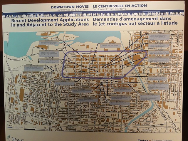
The January 18, 2012 Downtown Moves Open House was a low-key event with discussions around display panels and large printed maps of the study area. I have posted photos of all the display panels (except for two where people put dots on their home & work addresses and problem areas for walking and cycling). Here are the display panels: Downtown Moves - Open House Jan 18, 2012. UPDATE: Now includes the five sections of the large handout from the event, at the end of the photo set. ENDUPDATE I was fortunate to have the opportunity to have a long chat with the city's planning lead on the project, Nelson Edwards. I spoke about the importance of having a lively streetlife, of having interest and activity in the lower three stories of buildings as they engage the street (Jan Gehl has said these lower levels are key, where people on the street can see what's going on above and vice-versa for people living above). Mr. Edwards has a very comprehensive perspective, but I worry that the Downtown Moves initiative is challenged with being all things to all people. At its very core, it's about taking advantage of the buses being (partially) replaced by underground LRT, so that the study area (the Central Business District) can both adapt to the new pedestrian flows, as well as becoming a better urban environment as a whole. You can get a sense of the challenge from the many, many "Strategic Directions" the project has declared for the study area:
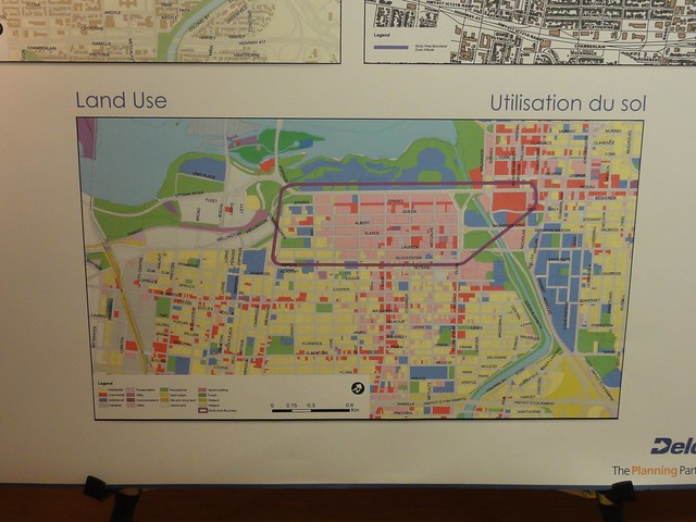
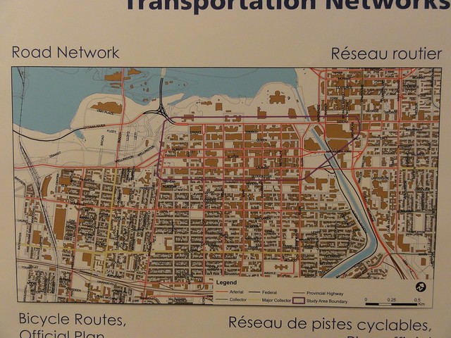
I think the core thing to understand about the CBD is that it is not a failure. It was designed to be that paragon of Modernist planning: the single-use district. They believed in strict separation of their three functions: dwelling, work, and recreation. All to be tied together with their fourth function: transport. In practice what this resulted in was people living in detached single family homes out in the suburbs, with work clustered in "office parks" downtown and along highways, and recreational areas separated from both. They really thought that this idea of the city as a "machine" or "factory", where you would separate out each function and make it "more efficient" would lead to the best possible living, working, and playing environments. The modernists also thought that all functions of the city planning should be separate with parks planning separate from traffic engineering separate from etc. etc. Instead of this mechanistic, reductionist planning producing efficient paradises it created lifeless surburban zones where people stay inside their houses, connected to lifeless work zones where people stay inside their buildings, connected to recreational zones where people stay inside the stadium. And by "connected" meaning only highway upon highway as single-occupant cars rush from one "function" to another. And the idea of buildings actually engaging with their environment, being in a specific place with people flowing in and out at ground level becomes so alien and lost that all your buildings turn inward, with dead exteriors surrounding interior food courts and shopping; buildings that could be dropped anywhere. They were totally wrong. Hey, it happens. But the result is most Ottawa families living a car commute away outside the greenbelt in cookie-cutter suburbs sprawling outwards, a CBD that cars and transit rush as quickly into and as quickly out of as possible at 9 and at 5, a hockey stadium out in the middle of nowhere, and endless expense on the car transportation (and to a much lesser extent transit) network needed to connect these far flung islands together. Even the arts centre in the core of the city turns its back to the sidewalk, because who would ever arrive anywhere by foot? Instead it welcomes the car on the canal side, far away from the rabble of the street. Plus which Rideau Centre in typical inward facing "special zone" fashion sucks up all the destination retail. This would be hard enough if we had stopped doing it. But most housing still goes beyond the greenbelt. Most new buildings (e.g. 180 Kent) continue the same inward-facing food court mall placeless design that Place du Portage and L'esplanade Laurier exemplify. New condos are dropped in as vertical suburbs, single-use residential zones that could be anywhere, with no engagement with the street. And the entire thing is held together with a network of high-speed city core "arterial" roads that makes the entire downtown an offramp. To unwind this deliberate 1960s successful design, we need to stop 50 years of assumptions, engineering and design. Many cities started doing this over two decades ago in the 80s and 90s. We have barely started to attempt it now, in the second decade of the 21st century. It will be a long long walk home. We've got the bones (and culture) of a small town with a couple main streets. We've got the housing of a small town that was packed with middle-class government employees. (See Residence Distribution of Civil Servants, 1947 from the Gréber Plan.) And we have the design of a wave of 1960s brutalism, "urban renewal", and Modernism, that left us with a city core stripped of inhabitants, a street rail system that was erased from the map, and the suburbs, malls and associated car infrastructure that swept across North American cities. I see this most often in the endless discussions around Sparks. Sparks had surface rail running down the middle, with destination shopping (the Apple Stores and Lululemons of their age) on either side. It connected Lebreton Flats to Lowertown and to the destination shopping on Rideau Street. It was surrounded by a dense grid of housing for civil servants, shop keepers and all the people who live in a typical central town. Then they took away the rail, all the destination shopping went to Rideau Centre, they flattened Lebreton, Lowertown crumbled into a low-income disaster area (like most city cores), all the rest of the people living downtown fled to the suburbs, and they dropped cold inward-facing office towers around Sparks. And people wonder why it doesn't work? It's a wide pedestrian street that connects nothing to nothing, with no shopping and no people who live nearby. In a real world where people like to move along edges, and watch other people. Is this seriously hard for people to understand? It's a pedestrian street in the middle of what might as well be a suburban office park. OF COURSE NO ONE WALKS THERE. Look at the reality It's a bunch of offices (pink colour) 
fed by a network of high-speed arterials (red lines)  Dedicated zones like this, with public space (that is to say, the streets) dedicated only to ensuring people can drive in and out AS FAST AS POSSIBLE are Dead by Design. You might as well stand at a strip mall by the Queensway and wonder why it isn't like being in downtown Paris. It will take decades of effort to unwind this. For example, the single biggest thing you can do to make this a place for the people who actually live there is to slow down traffic. It is insane to have high-speed traffic in a downtown core, a centre-ville. Over 30km/h, cars vs. pedestrians and cars vs. cyclists ends with dead citizens. That means you have to signal to people, through road design (not through signage or laws, which people ignore), through the design of the streetscape itself, that they not on the safe wide highway, that they have to slow down and pay attention, that they are now not the lords of carland, they are visitors to a pedestrian zone. Just that alone, trying to narrow and slow streets, returning them to their pre-1950s widths with attractive street features and enough uncertainty so that drivers go slowly with care, will be a huge, incredible fight. How do I know this? Because King Edward already tried to do this, and Bronson is trying to do it now, and the traffic engineers return instead with ever-wider, ever-faster, ever-more-highwaylike designs. This is not surprising, they are TRAFFIC ENGINEERS. Their purpose is to make the cars go faster and the traffic flow smoothly. Expecting them to produce traffic-slowing pedestrian designs is like expecting a pastry chef to design an aircraft carrier. If the city believes "Rebalanced and Equitable" streets, that means rebalanced and equitable planning. That means for every traffic planner, there should be a pedestrian planner, a cycling planner, and a transit planner. That's how you actually get to "rebalanced". This is not about hating cars or towers. This is about building a city, not a giant strip mall. Urban design is different from suburban design. The role of the car downtown is different. The way residential towers need to engage with the street is different. For that matter, the way people need to think about their city and move around it is different. There is a big risk that, as with the dead street life around the apartment towers full of thousands of people on Laurier west of Kent, if we drop more towers on Nepean and Gladstone near Elgin without using design and education to convey to people that they are in a city where they can walk around, shop, and live outside in the city, we'll just end up with a downtown that has "foot commuters" who pour out of residential towers, up into officer towers, and back again, without ever stopping to experience the city they're actually in. If you think this is theoretical, there are thousands of units in condo towers already approved, with many of the towers under construction right now.  The only way I can see to chip away at this realistically is: 1) The city must hire more dedicated pedestrian, cycling and transit planners (it has already taken great stride in hiring cycling planning, but has zero pedestrian planners). 2) The city must convey the idea, both through explicit statements and implicit design, decade by decade, that cars are visitors to the downtown, not the owners of downtown, and that they are welcome only to the extent that they respectfully share public transportation space with other users 3) The city must have zoning it can ENFORCE, design it can ENFORCE, and plans that are actually followed, in a way that is comprehensible to ordinary humans (as opposed to the current situation where developers build whatever they want wherever they want to the lowest possible standard, and use layer upon layer of city, NCC and other planning documents to win their case every time at OMB) There is so much more than even these basic steps. This is basically the project of the redevelopment of the entire urban design for the city. I am skeptical about what can be accomplished. I hope at least that it can move on three fronts, with small "popup" demonstration projects, enforced standards for new buildings, and a long term plan to make the city environment better as buildings are replaced and streets are upgraded. You can reach Nelson at Nelson Edwards Planning and Growth Management Department Infrastructure Services and Community Sustainability City of Ottawa 110 Laurier Street West Ottawa, ON K1J 1P1 Tel: 613-580-2424 ext. 21290 Fax: 613-580-2459 e-mail: downtownmoves@ottawa.ca You can sign up for the Downtown Moves mailing list. The city's website section for the project itself is ottawa.ca/downtownmoves This is a huge change in city direction. It needs every citizen pushing their councillors, city staff, and engaging in the planning process to help it happen. Labels: dottmo, downtown moves, ottawa, urban planning Sunday, January 15, 2012
Downtown Moves meeting January 18, 2012
Downtown Moves, which is the new name for the Downtown Ottawa Mobility Overlay, is having its second meeting Wednesday, January 18, 2012 5:30 to 8:30 pm Ottawa City Hall, Jean Piggott Place, Main Floor 110 Laurier Avenue West This is the second in a series of public events that will provide residents with an understanding of the study, what it hopes to achieve and how it will transform Ottawa’s streets over the next 20 years.The short URL is ottawa.ca/downtownmoves I'm using the Twitter hashtag #dottmo for the initiative. The previous events were more like stage-setting presentations, they didn't really delve into the project itself and its goals. What I would like it to be is: transforming the Central Business District (CBD) from a Monday-Friday 9am & 5pm commuter suburb in the core of downtown to a pedestrian-friendly 24/7 core with streetlife, connected to the Market, Centretown (south of the CBD) and Lebreton Flats. What I expect it will actually be is: How can we move commuters coming to/from the LRT stations out of the way of cars and in/out of their work towers as quickly as possible, while making some minor concessions to the fact that there are no longer buses on Albert & Slater. This is particularly important as Claridge and others have built a lot of condos in the area recently and are continuing. Just in the next few years another 2000 or more condo units will come online, mostly dropped into the CBD in giant towers. In theory, Downtown Moves should take into consideration the Centretown Design Plan, most specifically the recommendations that the downtown core arterials (particularly Lyon, Kent, O'Connor and Metcalfe) be made two-way. However the study scope is so narrow (just the CBD, just related to post-LRT) that I fear the Design Plan ideas will be lost. The short URL for the CDP is ottawa.ca/midcentretown but most of the information is in their blog in particular their final post: The FINAL Centretown Community Design Plan Has Arrived! (I hope the blog is archived, as the site and URLs will surely expire at some point.) There are many other relevant documents including the Pedestrian Plan and the Cycling Plan. I thought Greenberg's presentation from the previous meeting was going to be posted online, but I can't find it. I captured an archive of the November events and livetweeted Greenberg: Downtown Moves - Nov 1-3 Twitter archive. His book Walking Home is excellent. Highly recommended. Covers how the suburbs ate the cities, and how we can walk our way back to lively, people-friendly urban design. Ottawa has had no shortage of outside experts providing us excellent advice on modern urbanism. Where it falls apart is in two places: 1) Implementation using our actual city staff in our actual city 2) Funding and defending our decisions (e.g. enforceable zoning rather than development-via-OMB). HOME - |